Facing a Large Area of Dust Again in the North: Why is there so much wind and sand this spring?
2023-03-23
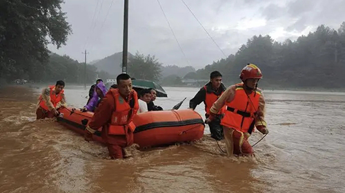
On the 22nd, there were many yellow sands in the north. This round originated from the sandstorm weather in central Mongolia and northwest China, and has affected 18 provinces, regions, and cities in recent days. It is characterized by a large range of sand occurrence, wide coverage, fast movement speed, and heavy peak pollution. Due to its impact, some areas in southeastern Inner Mongolia, Beijing, northern Tianjin, and central and northern Hebei have sand and dust storms, and local areas have strong sand and dust storms. Where does this round of dust come from? Why are there so many sandstorms this spring? What is the ecological situation of the sand source area? Journalists interview relevant institutions for interpretation. Where does this round of dust come from? On the 22nd, the Beijing sky at the "morning peak" was gray and yellow, and the air was filled with the smell of dust. Vehicles walked slowly on the road, and pedestrians walked in a hurry, with a clear sense of particles on their faces. "Sandstorm", "Dirty", "How to Prevent Sandstorm Weather" and other topics have become social media "topic words", and many netizens have shared the "Sandstorm Experience". Others jokingly said that the "Youth League" in the south and the "Lvdagur (Glutinous Rice Rolls with Sweet Bean Flour)" in the north represented the different "spring scenery" in the north and south. According to the comprehensive presentation of satellite images and ground monitoring information, with gusts of strong winds, many provinces, regions, and cities in the north are shrouded in yellow sand, and the sky and earth are covered with yellow or even orange "filters". The dust originated in central Mongolia and northwest China, covering a maximum area of nearly 1 million square kilometers. According to the "Remote Sensing Map of Cloud Microphysics in the Northern Region" from the Beijing Ecological Environment Monitoring Center, since the 21st, due to the impact of strong winds at the back of the low pressure in Mongolia, there has been a large-scale phenomenon of sand formation in the sand source areas in the central and eastern regions. On the night of the 21st, sand and dust entered China, with a wide sand and dust belt. The concentration of PM10 in a large area from Northeast China to Gansu reached the level of "serious pollution", with the peak value of some stations approaching 10000 micrograms per cubic meter. At 3:00 am on the 22nd, foreign sand and dust affected Beijing under the strong northwest wind, and the air quality was rated as "severely polluted". At 8:00 on the 22nd, the main body of sand and dust overflowed Beijing. The concentration of PM10 in Beijing was 1449 micrograms per cubic meter in the sixth district of the city, 1498 micrograms per cubic meter in the northwest, 1825 micrograms per cubic meter in the northeast, 1799 micrograms per cubic meter in the southeast, and 1638 micrograms per cubic meter in the southwest. Du Jia, the chief forecaster of the Beijing Meteorological Observatory, said that due to the impact of cold air, strong winds, and upstream transportation, on the 22nd, Beijing upgraded its "Yellow Dust Storm Warning" signal, indicating that a large number of allergens such as pollen and dust mites, as well as bacteria and viruses, may be mixed during spring dust weather, which may induce allergic reactions and respiratory diseases. During sandstorm weather, the elderly, children, and people with respiratory allergic diseases should minimize going out. For outdoor activities, it is necessary to wear masks for protection, and as appropriate, wear goggles and gauze to cover the eyes, nose, mouth, and ears. Why are there so many sandstorms this spring? "Sand and dust weather" is divided into different categories according to factors such as whether ground dust and sand blow up, horizontal visibility, and other factors, such as floating dust, blowing sand, sandstorms, strong sandstorms, and extremely strong sandstorms. According to the Meteorological Publicity and Science Popularization Center of the China Meteorological Administration, three conditions need to be met to form a sandstorm: first, strong winds as a power source; The second is the source of sand and dust as the material basis; Third, unstable air conditions that cause sand and dust to rise higher. Data statistics show that the temperature rises rapidly in the spring of March, and the northern sand source areas begin to thaw
Edit:He Chuanning Responsible editor:Su Suiyue
Source:Xinhua
Special statement: if the pictures and texts reproduced or quoted on this site infringe your legitimate rights and interests, please contact this site, and this site will correct and delete them in time. For copyright issues and website cooperation, please contact through outlook new era email:lwxsd@liaowanghn.com
 Recommended Reading Change it


 Home
Home